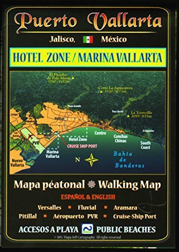
A highly detailed, full-color, panoramic map of Puerto Vallarta’s northern coastal neighborhoods, this map picks up where Mapa Jeff’s Puerto Vallarta Centro & South Coast Walking Map leaves off, at the north edge of the Old City. At a compact folded size of 5 x 7 inches, it is easy to peruse while on foot or behind the wheel. Full (unfolded) size is 14 x 20 inches. Side A shows the Hotel Zone, Fluvial, Versalles, and neighborhoods north to Pitillal’s colorful central plaza. The cruise-ship port is illustrated with gate and pier numbers, parking, and taxi stands for cruise passengers striking off on their own for the day. Side B shows Marina Vallarta and an inset map of Vallarta’s northern reaches, showing key routes out of town to the mountains and Nayarit. MAPA JEFF (Jeffrey F. Obser) is a professionally trained journalist and editor who took up illustrative cartography during long residence and research on-site in Mexico. His maps portray the land in an unconventional three-dimensional style that is both easy to grasp and filled with useful current information. All Mapa Jeff maps are printed in small batches and updated frequently as information changes.